
“], “filter”: { “nextExceptions”: “img, blockquote, div”, “nextContainsExceptions”: “img, blockquote, a.btn, a.o-button”} }”>
Heading out the door? Read this article on the new Outside+ app available now on iOS devices for members!
>”,”name”:”in-content-cta”,”type”:”link”}}”>Download the app.
Joshua Tree National Park gets over 3 million visitors a year; in 2023, it was the ninth-most visited national park. If you’re looking to enjoy this iconic desert landscape away from the crowds, embark on the California Riding and Hiking Trail (CRHT), a peaceful, remote 36.5-mile trek across the park. I completed the hike over Thanksgiving weekend and collected plenty of tips and tricks for the trail.
Highlights of Joshua Tree National Park and the CRHT
When I think of the word ‘desert,’ a barren, desolate plain comes to mind. Joshua Tree is very much the opposite. Its position at the intersection of the Mojave and Colorado desert ecosystems creates an expansive, mountainous landscape with over 750 plant species.
My absolute favorite aspect of the CRHT was just how remote and isolated it was. Over the course of three days of hiking, I only saw two trail runners, four day hikers and four backpackers. This was during the Thanksgiving holiday, when the lines of cars waiting to enter the park went for miles. I was looking for a quiet few days in the desert, with time and space for introspection and meditation, and the CRHT delivered.
Of course, there are also beautiful landscapes and natural features to take in along the trail as well. On my second day, while in the Covington zone, I hiked a high ridge, with steep drops off on each side. In the distance on one side were the Little San Bernardino Mountains, and on the other was Quail Mountain, the highest point in the park at 5,816 feet. Funky, almost Dalí-esque rock formations are a constant companion on the trail; some of the named formations you’ll see include Cap Rock and Split Rock. Your other constant on the trail are the Joshua trees; I thought that after 3 days, I’d get tired of looking at these wonky trees that look like they belong in a science fiction film, but my wonder remained. The trees are like snowflakes; no two Joshua trees look the same.
California Riding and Hiking Trail Basic Information
- Length: 36.5 miles. I completed the trail in three days, but it could be done in four.
- Location: The trail’s two termini are the Black Rock Canyon Trailhead and North Entrance Trailhead. I would recommend going from Black Rock to North Entrance, since the reverse would involve a much longer, prolonged ascent.
- Best Time to Hike: October to December or March to May. Avoid the summer months, where temperatures often reach triple digits. Even if hiking in cooler temperatures, be sure to bring sunscreen and sun protection, as there is very little shade on the trail.
- Wildlife and Insects: Joshua Tree National Park is home to 57 species of mammals, 46 species of reptiles and 250 species of birds. I saw very little wildlife beyond birds on my hike, and noticed no mosquitos or other irritating insects. It’s recommended to keep your food and backpack with you in your tent at night to avoid any critters getting at your supplies.
- What’s Nearby: The towns of Yucca Valley, 29 Palms, and Joshua Tree are all within a short drive of the park should you need to stock up on food or gas.
Permits
Anyone staying overnight in the backcountry must acquire a permit, which are available at recreation.gov. They cost $6 and rarely book up fully. Visitors without an America The Beautiful pass must also purchase entry to the park, which costs $30 and lasts for 7 days.
Transport
As someone coming from out of state, I flew into the Palm Springs Airport, rented a car and drove the approximate hour to the park, and this worked well. I parked my car at the endpoint (North Entrance trailhead) and got an Uber back to Black Rock Canyon Trailhead to start my hike (which cost around $85). Cell service in the park is spotty, if nonexistent, so it’s best to schedule an Uber ahead of time. As of this writing, there is no shuttle or public transportation in the park.
Water
There is no water available on the route, but hikers are welcome to cache water. I started with 7 liters and dropped an additional 3.5 at the approximate halfway point at Juniper Flats trailhead (sometimes also called Keys View), and that was sufficient. Be sure to use a heavier plastic container like a Nalgene for your cache, as wildlife can get into thin plastic water jugs from the grocery store. Write your last name and the date of the pickup on the container.
Trail Conditions
The terrain on the trail is a mix of loose sand, compact dirt and rocky, loose scree, making sturdy boots and trekking poles a necessity. The trail has signposts every mile, which was helpful because the trail can be faint, and at times it could be easy to accidentally mistake a wash for the trail. I appreciated having this map with me, since there also many side trails that offshoot from the CRHT.
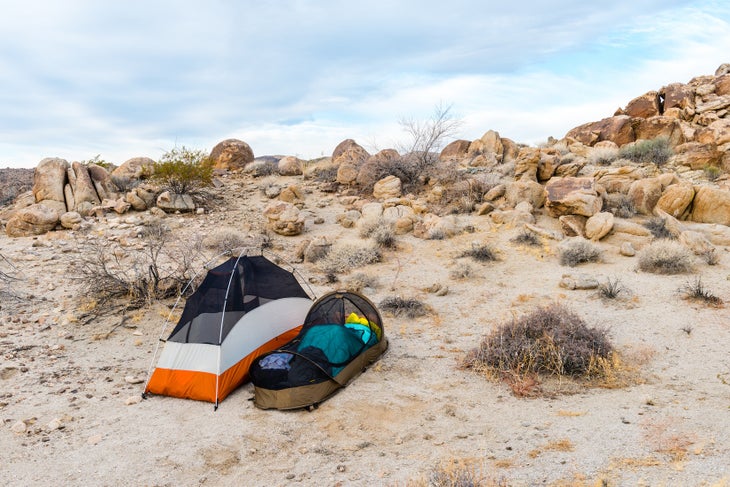
Camping
There are no designated backcountry campsites on the CRHT. The park is split up into various zones, and when registering for a permit, you indicate which zone you will be sleeping in each night. With this comes a couple rules: You have to set up camp at least one mile from trailheads, half a mile from roads and 200 feet from the trail, ideally not on vegetation. Hanging hammocks on Joshua Trees is not permitted; fires are also not allowed. My itinerary was the following: camp in Covington (mile 14), camp in Lost Horse (mile 28) and finish the trail on day 3.
I really enjoyed the freedom of deciding where I wanted to camp while in the backcountry. I could listen to my body and decide when I wanted to be done hiking for the day, rather than being limited by a prescribed site. Along the entire trail, there were plenty of flat, vegetation-free washes to camp in. It is worth noting that hikers shouldn’t camp in washes if there is rain in the forecast, as they can become flash food zones.
How Hard is the CRHT?
The first day of the hike is the most physically challenging; for the 7.5 miles between Black Rock Canyon and Upper Covington Flats trailhead, the trail ascends around 1,200 feet. The rest of the trail in this direction, however, is mostly flat or gently downhill. Given how remote the trail is and the challenge that waymarking can pose, backpackers should have at least a moderate amount of backcountry experience before they attempt this trail.